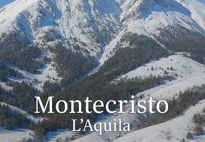
Montecristo · Gran Sasso d’Italia
Overview
A quiet summit on the L’Aquila side of the Gran Sasso, with wide views over the basin and natural links towards Campo Imperatore.
Montecristo is a secondary but very interesting summit of the Gran Sasso d’Italia massif. It lies on the L’Aquila side and offers a quieter environment than the more famous destinations such as Corno Grande or the Duca degli Abruzzi hut. Its slopes once hosted a small local ski area, now abandoned, and are perfect for hiking, traverses and ski touring.
Area
Fonte Cerreto · Assergi · L’Aquila
Environment
Woods, clearings, open slopes
Best for
Experienced hikers · Ski tourers
Character
Quiet, little‑frequented
Note: Montecristo is not a village but a summit of the Gran Sasso d’Italia,
reached via the same access roads as Campo Imperatore.
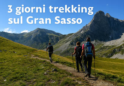
Hiking routes
Hiking on Montecristo
Trails climbing from the Fonte Cerreto and Assergi valleys to panoramic slopes and open ridges.
Ascent to Montecristo from Fonte Cerreto / Assergi
- Difficulty: E (hiking)
- Elevation gain: ~600–800 m
- Time: 2h – 2h 30’
- Season: spring · early summer · autumn
From the valley floor (Fonte Cerreto / Assergi area), the route climbs along paths and old ski tracks towards the slopes of Montecristo. It crosses woods and clearings, then opens onto broader, more panoramic slopes, with fine views over the L’Aquila basin and the western side of the Gran Sasso.
Traverse Montecristo – ridge towards Campo Imperatore
- Difficulty: E/EE
- Total elevation gain: 800–1,000 m
- Time: 4h – 5h
From the upper part of Montecristo you can follow the ridge towards Campo Imperatore, along paths and tracks over ridges and basins. It is a very panoramic route, suitable for experienced and well‑trained hikers, and gives a strong sense of the massif’s continuity.
Loop hikes on the slopes of Montecristo
- Difficulty: E
- Elevation gain: 400–600 m
- Time: 2h – 3h
Short loops can be created using old forest roads, service tracks to the former ski lifts and local paths. They are perfect for half‑day hikes, training and photography.
Winter & mountaineering
Winter routes and ski touring
Regular, wide slopes, ideal for classic ski touring and winter ascents with crampons.
North and north‑west slopes (ski touring)
- Difficulty: BS (ski touring) / EE in winter conditions
- Slopes: 30–35°
- Season: January – March (depending on snow)
The slopes of Montecristo offer regular, wide terrain suitable for classic ski touring. It is ideal for those with basic experience who want alternatives to the more famous lines of the Gran Sasso.
Winter ascents on foot
- Difficulty: EE
- Gear: crampons, ice axe, proper winter clothing
The summer routes can also be followed in winter with firm snow and clear views. It is essential to carefully assess snow and avalanche conditions, especially on steeper slopes.
Warning: with wind‑blown or unstable snow, the open slopes of Montecristo
can be prone to avalanches. Always check avalanche bulletins.
Ski history
The former Montecristo ski area
Traces of a small local ski area: short pistes, a ski lift and a story that tells the evolution of Apennine skiing.
Montecristo is linked to the memory of a small local ski area, now completely abandoned. It served slopes suitable for beginner and intermediate skiers, mainly used by locals and guests staying in the Fonte Cerreto / Assergi area.
With the development of Campo Imperatore and the growth of other ski resorts such as Campo Felice and Ovindoli, the Montecristo area was gradually abandoned as a ski station. Today, traces of the pistes remain as linear clearings, concrete bases and former service structures.
Why visit today: to read the history of small local ski lifts in the
landscape and imagine what skiing on the Gran Sasso was like a few decades ago.
Nature & landscape
Environment
Montecristo is surrounded by beech and oak woods, panoramic clearings and typical central Apennine environments. Wildlife includes foxes, roe deer and birds of prey, with good chances of observation during the quieter hours of the day.
From the slopes and ridges there are wide views over the L’Aquila basin, the Gran Sasso and the surrounding ranges. In autumn, the colours of the woods make the area particularly scenic.
How to get there
Access
Montecristo is reached via the same roads that lead to the Gran Sasso (Fonte Cerreto / Assergi area), about 20–30 minutes from L’Aquila. Trailheads are located along the access roads and in areas already used as bases for hikes on the massif.
It is advisable to park in already consolidated areas and start on foot, following local paths and tracks, avoiding creating new lines across meadows and clearings.
Suggestions
Practical tips
- Weather and snow: always check weather and snow conditions, especially in winter.
- Water and food: no services at altitude, bring supplies.
- Summer: sun protection, hat and care on exposed slopes.
- Winter: crampons or micro‑crampons, poles, layered clothing.
- Crowds: ideal for those seeking quieter routes than the classic Gran Sasso itineraries.
Important: even though Montecristo is a “secondary” summit, it still
requires hiking experience and good navigation skills, especially in fog or snow.